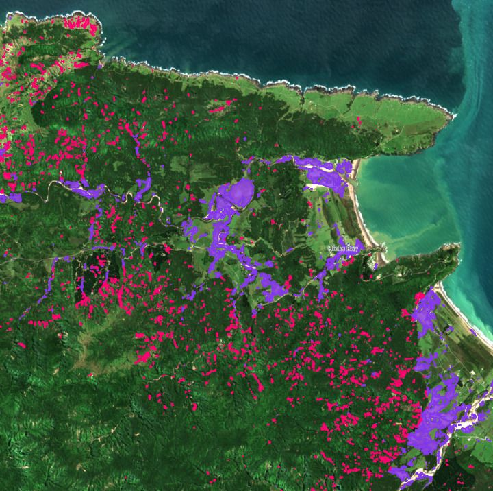
A satellite map reveals the scale of devastation across the East Cape following the January 2026 storm, identifying more than 11,000 landslips, and silt damage covering an area of 900 hectares, as communities remain isolated due to road blockages.
Dr Yvan Richard and Kusal Ekanayake developed the East Coast Slip Map to provide a region-wide overview of the damage, identifying visible evidence of landslides and silt movement by comparing satellite imagery taken before and after the storm.
Dr Finlay Thompson, Director of Data Science at Dragonfly, says that the goal was to create a clear, accessible, and large-scale snapshot of what happened across the area.
“Satellite imagery should be viewed as a crucial response tool in the aftermath of any disaster,” says Thompson. “It provides a birds-eye view of the area following an intense and highly localised storm event such as this one, and allows for individual slips and silted areas to be identified.”
“We hope this map helps build a clearer picture of how the landscape responded to the storm, supporting landowners, councils, and government agencies with the cleanup”
While this recent storm was more geographically contained than some past events, the map shows significant damage concentrated along the northern end of the East Cape region, with many slips occurring along coastal hill flanks rather than in higher inland areas.
This satellite mapping approach has previously been validated in New Zealand by GNS, where Dragonfly used similar methods to develop a Cyclone Gabrielle impact map that identified flooding, slips, and affected communities, to support response and recovery planning.
Thompson says events like this highlight a growing need to bridge the gap between disaster response and long-term climate preparedness.
“Cyclone Gabrielle was only the start of the extreme weather events that are becoming more frequent in Aotearoa, and we need better tools and planning in place ahead of time,” says Thompson.
“By linking storm impacts with rainfall and terrain data over multiple events, we could begin to build models that help predict where slips and flooding are most likely to occur in future.”
“People’s livelihoods are at stake. While response and recovery efforts are critical and effective, the reality is that communities are living through significant disruption and loss in the meantime---and that’s something we can’t afford to treat as normal.”
The coastal road between Te Araroa and Pōtaka remains closed, isolating Hicks Bay, as crews work to stabilise multiple slips, including major sites at Waikura and Punaruku. The Punaruku slip alone is estimated to involve around 250,000 cubic metres of material. Although there has been progress in restoring limited access for critical supplies and emergency services, ongoing land instability means there is currently no confirmed timeframe for reopening the route to the public.
Contact us
For assistance with further data analysis relating to satellite data and land cover, please get in touch via hello@dragonfly.co.nz or call us on +64 4 385 9285.
More information
- Explore the East Cape Slip Map.
- Download the slip and silt data as a GPKG file for use in GIS systems. These data are made available under a Creative Commons Attribution Licence. You are welcome to reuse and redistribute the data, provided that credit is given to Dragonfly Data Science.
- Read a description of the immediate impact of the flooding, from Radio New Zealand.
- Read about previous work on the impact of Cyclone Gabrielle.